14 beautiful photos of the Earth from above

a land mass surrounded by water

Located in the center of the Iranian plateau, the Dasht-e Kavir, or Great Salt Desert, is the 24th largest desert on the planet. From the ground, the desolate sand plains and adjacent mountain range are imposing and beautiful. From above you get a completely different perspective. The US Geological Survey-operated Landsat 7 satellite captured a stunning image of the Dasht-e Kavir from above in 2000 (seen below). The Landsat 7 satellite operated from 1999 to 2024.

The Dasht-e Kavir, or Great Salt Desert, is the largest desert in Iran. It is mainly an uninhabited wasteland, consisting of mud and salt marshes covered with salt crusts that protect the scarce moisture from complete evaporation. This image was taken on October 24, 2000 by the Landsat 7 satellite. It is a false-color composite image created using infrared, green and red wavelengths. The image has also been sharpened using the sensor’s panchromatic band.
Credit: NASA/USGS Landsat 7; NASA Earth Observatory

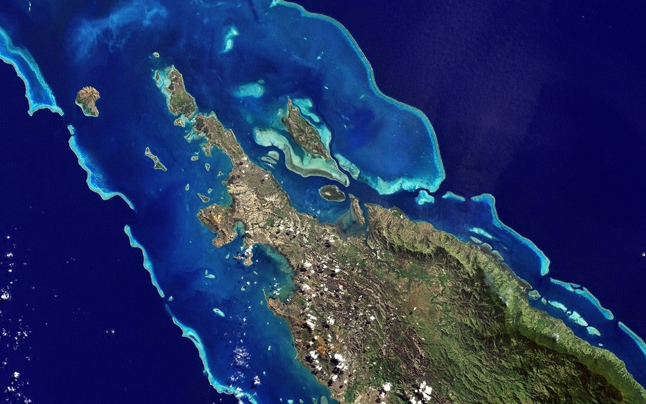
The Landsat 7 satellite isn’t the only craft capturing images beautiful images of our planet from above. Other International Space Station satellites and crews have also documented Earth, taking images everywhere from Georgia, US, to the islands of New Caledonia in the South Pacific.

clear water meets the shore
In a dense swampland in Georgia, just north of the Florida border, you’ll find the headwaters of the Suwannee River (above right). The Suwannee is known as a ‘blackwater river’ because of its dark brown water loaded with organic matter. This river system has been called one of the most pristine in the United States, but certain environmental pressures are jeopardizing that distinction.

Unlike other blackwater rivers, the Suwannee retains its inky color throughout its entire 250-mile journey to the sea. When the river eventually meets the Gulf of Mexico along Florida’s Big Bend — that part of the coast where the state’s panhandle curves toward the peninsula — the dark water acts as a tracer, revealing where the river water mixes with the sea.

That mixing was seen on February 20, 2015, when the Operational Land Imager on NASA’s Landsat 8 satellite captured this image.
Credit: NASA Earth Observatory image by Dr. Alice Alonso, using Landsat satellite data from the US Geological Survey. Caption adapted from Laura Rocchio, NASA Landsat Science Outreach.

ice swirls in blue water
Like distant galaxies amid clouds of interstellar dust, chunks of sea ice float through graceful swirls of grease ice in the icy waters of Foxe Basin near Baffin Island in the Canadian Arctic. Sea ice often starts as fat ice, a flexible layer of small ice crystals on the ocean’s surface. As the temperature drops, the fat ice thickens and coalesces into slabs of firmer ice.

This image was acquired on August 4, 2002 by the Landsat 7 satellite.
Credit: USGS/NASA/Landsat 7

water and land in broken peaks
This image showing the tidal flats and channels on Long Island, Bahamas, was taken by an Expedition 26 crew member aboard the International Space Station. The islands of the Bahamas in the Caribbean Sea are located on large platforms made mainly of carbonate sediments surrounded by reefs on the edge – the islands themselves are just the parts of the platform that are currently above sea level. The sediments are formed mainly from the skeletal remains of organisms that settle on the seabed; over geological time, these sediments will consolidate to form carbonate sedimentary rocks such as limestone. Darker blue indicates deeper water, while light blue-green indicates shallow water on the mud flats. The continuously exposed parts of the island are colored brown, due to soil formation and vegetation growth (left).
Credit: Expedition 26 crew member aboard the International Space Station, courtesy of NASA
swirling plankton in the water off the coast
Each summer, phytoplankton spread across the northern basins of the North Atlantic and Arctic Ocean, with blooms extending for hundreds and sometimes thousands of kilometers. Nutrient-rich, cooler waters tend to promote more marine plant and phytoplankton growth than tropical waters. The flowering in the summer of 2018 outside Scandinavia seems to be particularly intense.

On July 18, 2018, the Operational land imager (OLI) on Landsat 8 acquired a natural-color image of a swirling green phytoplankton bloom in the Gulf of Finland, part of the Baltic Sea. Notice how the phytoplankton follow the edges of a vortex; it is possible that this ocean vortex is pumping up nutrients from the depths.
Credit: NASA Earth Observatory images by Joshua Stevens and Lauren Dauphin, using Landsat data from the US Geological Survey and MODIS data from LANCE/EOSDIS Rapid Response

icy glaciers and water
From NASA’s Operation IceBridge campaign in Alaska: A high-altitude view of Icy Bay, in the Wrangell-Saint Elias Wilderness. Only a century ago this water was covered with ice.
Credit: NASA
flat circular cloud
Perhaps the most impressive cloud formation, cumulonimbus (from the Latin for ‘pile’ and ‘rain cloud’) are formed as a result of vigorous convection (rising and falling) of warm, moist and unstable air. Surface air is heated by the sun-heated ground surface and rises; if sufficient humidity is present, water droplets will condense when the air mass comes into contact with cooler air at higher altitudes. The air mass itself also expands and cools as it rises due to decreasing atmospheric pressure, a process known as adiabatic cooling. This type of convection is common year-round at tropical latitudes and during the summer season at higher latitudes.

The image, taken while the International Space Station was over West Africa near the Senegal-Mali border, shows a fully formed anvil cloud with numerous smaller cumulonimbus towers rising near it.
Credit: NASA

water sand and land
Canada’s Mackenzie River plays an important role in the Arctic climate as warmer freshwater mixes with cold seawater.
This image was taken on July 18, 2017 by the Operational Land Imager on the Landsat 8 satellite.
Credit: Source: NASA/USGS Landsat 8; Norman Kuring, GSFC
circular formation of rocks
This beautiful image, taken on January 11, 2001, shows a geological formation in the Maur Adrar Desert in Mauritania, Africa. Known as the ‘Richat structure’, this snail shell-like formation was formed when a volcanic dome hardened and gradually eroded, exposing onion-like layers of rock.
Credit: NASA/US Geological Survey/Landsat-7/Goddard Space Flight Center
dark lake
Dagze Co (lake) is one of the many inland lakes in Tibet. In ice ages the region was considerably wetter and the lakes were correspondingly much larger. This is evident from the numerous fossil shorelines that encircle the lake, testifying to the presence of a larger, deeper lake. Changes in climate have resulted in increased aridity of the Tibetan plateau and the drying up of the lakes. Image taken by the Advanced Spaceborne Thermal Emission and Reflection Radiometer (ASTER) on October 8, 2001.
Credit: NASA/GSFC/METI/ERSDAC/JAROS and the US-Japan ASTER Science Team
reddish land and clear blue water
Guinea-Bissau is a small country in West Africa. Complex patterns can be seen in the shallow waters along the coastline, where silt carried by the Geba and other rivers washes into the Atlantic Ocean. Photo taken by Landsat 7 on December 1, 2000.
Credit: USGS/NASA/Landsat 7
swirling plankton surrounds an island
In the style of Van Gogh’s painting ‘Starry Night’, enormous amounts of greenish phytoplankton swirl in the dark water around Gotland, a Swedish island in the Baltic Sea. Phytoplankton are microscopic marine plants that form the first link in almost all food chains in the ocean. Population explosions or phytoplankton blooms, such as those depicted here, occur when deep currents bring nutrients to sunlit surface waters, stimulating the growth and reproduction of these tiny plants. Photo taken by Landsat 7 on July 13, 2005.
Credit: USGS/NASA/Landsat 7
chunks of ice floating near a snow-covered island
This photo taken on January 22, 2001 by the Landsat-7 satellite shows Akpatok Island, located in Canada’s Ungava Bay. Reachable only by plane, Akpatok Island rises from the water as sheer cliffs rising 500 to 800 feet (150 to 243 meters) above the sea surface. The island is an important refuge for cliff-nesting seabirds. Numerous ice floes around the island attract walruses and whales, making Akpatok a traditional hunting ground for indigenous Inuit people.
Credit: NASA/USGS Landsat 7 satellite; NASA Earth Observatory

Win the holidays with PopSci’s gift guides

Shopping for, well, anyone? The PopSci team’s holiday gift recommendations will ensure you never have to buy a last-minute gift card again.

Source link

See also  Apple iPad Pro (2025) Release date, price and specifications