Travelling from Nelson to Invercargill is a bit of a trip. Check the best route on Google Maps, travel on formed state highways, usually with a night or two somewhere along the way in comfortable and warm accommodations. In 1856, the trip on horseback took a bit longer and was neither easy nor comfortable, although possibly more of an adventure.
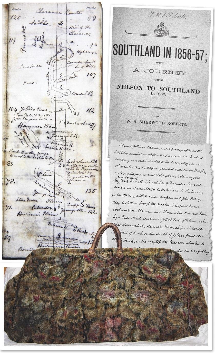
William Henry Sherwood (W.H.S.) Roberts was known as a literary man and wrote among other things Southland in 1856-1857; with a Journey from Nelson to Southland in 1856. In the Waitaki Museum and Archive Collection we hold his personal copy, which contains many handwritten notes, photographs and drawings. These additions to the original publication are varied and make corrections to some text, note when people died and reference new information.
Born in Tenby, Wales, Roberts began studying medicine but ended up studying as a bookkeeper and land surveyor. He left for New Zealand before becoming licensed as a surveyor and arrived in Nelson on the John Phillips in May 1855.
On April 23, 1856, Mr Roberts and friend Mr Henry Young left Nelson on horseback, leading a horse packed with tent, blankets, change of clothes, food, hobbles and a tethering rope. They also carried a compass, which they found very useful.
The book describes the journey in detail, including comments about the weather, scenery, birdlife and people they met along the way.
Glued on to the front cover of the book is Roberts’ sketch of the route from Nelson to Southland in 1856, which he added in 1858. This small and detailed insert shows the distance in miles, mountains, rivers, towns and whare. The image above shows one page of the little map — it has the meander of the Clarence River, Jollies Pass, the Hurunui Plain and river.
Page eight of the book describes the following: “29th The wind blew a strong gale all night, followed in the morning by heavy rain, so we could not light a fire. We had to breakfast off biscuits, and mounted on our horses at half-past seven. About a mile down we came to a picturesque gully on the north east side, wooded at the head and dotted here and there with clumps of black birch on both sides. We crossed the Clarence four times, the valley was narrow with spurs jutting on to the river. About three miles from our camp we struck the track from Barefells Pass, and observed Jollies Pass a little to the south west.”
In between pages eight and nine, Roberts inserted a page referring to Edward Jollie’s discovery of the pass.
In the edition of the book reprinted by the Southland Times, Roberts writes in the preface, “If I have assisted in saving a few useful memoranda from oblivion, and giving pleasure to the readers, my object in having these notes printed has been accomplished”.
The sketched map, notes, drawings and photographs Roberts has included in the copy the museum holds really brings his narration of the tough and long ride from Nelson to Southland alive.
Roberts lived in Oamaru from 1879 until his death on January 23, 1917. He built his home “Marapua” at Meadowbank, on what is now now Thames Highway, in Oamaru.
Elly Dunckley is curator of archive at Waitaki Museum and Archive Te Whare taoka o Waitaki.


Leave a Reply