

Westland flooding
• State Highway 6 from Fox Glacier to Haast is closed
• Stay off the roads and away from flooded areas if possible
• If you require emergency accommodation (ie you have nowhere to stay) please contact West Coast Emergency Management (03) 769 9323
The heavy rain that has been pounding Westland is easing and officials hope to start assessing on Sunday how much damage has been done to the highway network.
Southern Westland remained under a local state of emergency on Saturday night as Franz Josef experienced its wettest 24 hours in 45 years.
Mayor Helen Lash made the declaration on Saturday morning after 375mm of rain fell across the coast in the 24 hours to 7am.
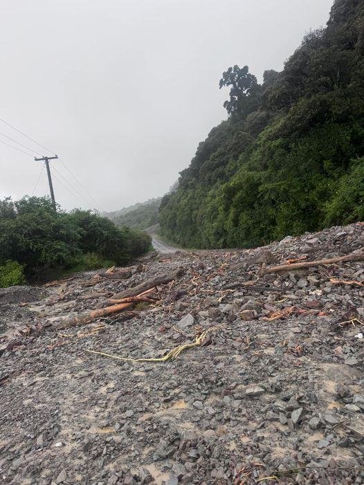
State Highway 6 between Fox and Haast is closed due to flooding and slips, but the section between Haast and Makarora had reopened.
Civil Defence controller Kevin Hague told RNZ officials would be making contact with communities around the district to assess the damage on Sunday.
Water levels on the Whio, Haast and Hokitika Rivers were dropping after triggering level one alerts earlier on Saturday.
The rain had been pummelling the region, including the Grey and Buller districts, with orange level rain warnings in place for Westland.
Lash declared a state of emergency for most of South Westland at 9.42am on Saturday.
Flooding pushed through houses near Haast and there were concerns regarding an existing slip side at Epitaph Cutting – which has closed SH6.
There were floodwaters in homes at Haast, with Hannahs Clearing badly hit. Video showed people kayaking down the street.
The NZ Transport Agency/ Waka Kotahi said on Saturday morning there had been movement at Epitaph near Knights Point, which first slipped in 2016 and it needed to get Geotech experts on site.
However, it expected the highway to remain closed all weekend, though other slips and falls elsewhere on SH6 would be cleared.
“Our crews will continue to clean up the fallen trees and slips around Bruce Bay, the glacier towns and south of Ross, but the Knights Point cracks are of more concern,” Mark Pinner, system manager for NZTA in the central South Island, said in a statement.
“We will have a surveyor on site this afternoon and more geotechnical inspections by chopper on Sunday morning to assess the area at Knights Point. SH6 through Knights Point area will remain closed for the weekend, with the next update for the route between Fox Glacier and Haast at 10am Monday.”
There was no detour route for SH6 at Knights Point. People wanting to get to Greymouth or Hokitika would need to come via Arthur’s Pass (SH73) or the Lewis Pass (SH7) from the east coast for the time being, or delay their journeys.
SH6 from Ross south to Fox Glacier was closed but NZTA advised on Saturday evening that it had reopened. Fox Glacier south to Haast remains closed, likely through until Monday morning.
At Haast, Kerry Eggeling said quite a few houses had water in them, at Nolans Rd. He also had reports of “some guys in a hut up a side road in their waders standing on a table”.
Eggeling emptied his rain gauge at 6.30pm on Friday, which was overflowing by 6.30am on Saturday. In 12 hours, they had 170mm to 180mm of rain.
The rivers were quite high and although the rain had eased, the rivers were still rising at 9am, several hours after high tide.
“We think the Okuru bridge might dam the water up a bit,” he said.
He had seen video of the Epitaph slip which showed the road had dropped and there was a great big crack.
“The hill detour has filled with a slip. That road will he closed for days – if not weeks.”
At Jackson Bay Rd, Eggeling said he had seen a picture of a slip with gravel halfway up power pole.
At Hari Hari, Wanganui Flat Rd gardens went under. Robertson Rd also flooded.
By 9am on Saturday, Greymouth had received just under 30mm of rain in 24 hours.
Haast though had received almost 500mm at Roaring Billy, Hari Hari 249mm, Hokitika 49mm, and Franz Josef 419mm. Whataroa also got an impressive 300mm.
There were reports on social media of water in houses at Hannahs Clearing.
The Haast to Jackson Bay Rd was also unpassable.
Despite the deluge, Hari Hari fire chief John McIntosh, said there were “no problems that I know”.
At Franz Josef for Civil Defence, Wayne Costello all was okay although there had been a lot of rain.
“The stopbanks are looking pretty good.”
The Waiho (Wauia) River went through its first stage alarm about 4am on Saturday, but there were two regional council engineers on site and they were pretty happy.
Gerry McSweeney reported a slip at Lake Moeraki and a substantial one at Venture Creek.
West Coast Emergency Management said the state of emergency declaration “provides for Controllers to direct and coordinate personnel, material and other resources made available and provides access to extraordinary powers to deliver an effective and timely response to an emergency.
“Members of the public are reminded to prepare getaway bags in preparation for potential evacuations. If anyone is feeling unsafe, please self-evacuate to friends or family on higher ground or call 111.”
Minister for Emergency Management and Recovery Mark Mitchell was in the West Coast on Saturday to assess the situation and to support local response efforts. Earlier, he urged residents to stay off the roads as heavy rain continued.
MetService advised on Saturday the situation was improving, with the front moving north and the rain clearing the West Coast through the afternoon and evening.
– additional reporting RNZ/ODT Online
